Going beyond the digital divide
Interview with Monica Sanders Founder of The Undivide Project
1. Tell us about The Undivide Project (TUP), where the idea came from and its impact.
The Undivide Project‘s name is taken from the “digital divide” and its impact on communities. Our initial work was about undoing that divide. Therefore “Undivide” Project. We quickly understand that the same communities that were underinvested in or divested from digital infrastructure (Internet, AI, digital skills) were also the same ones that faced water and energy scarcity problems and outsized risk of climate impacts. I first understood it when I was working on a community WIFI project with colleagues in Baltimore. We were walking around the neighborhood and saw that the same places with no access to the Internet were the ones with watermarks from flooding around their steps and suffered from urban heat issues. That’s when we decided to focus on this critical intersection.
Since we started in 2022, we have worked in eleven states and Puerto Rico, partnered with four universities as well as policy organizations such as New America and The Federation of American Scientists. I’m most proud of the fact that the community we first started working with in Baltimore is now one of our strongest partners in helping others. We are collaborating now on some AI access x water justice x urban heat projects.
2. You all have developed a variety of tools to help communities, what’s your process for working with communities to define tools they need? Can you share a success story of a community utilizing these tools.
We usually ask people what they want and then we make it. Earlier this year, when it became clear that a lot of public information would be less available, we started asking partners about which issues worried them most. Many of them said they were worried about vulnerable groups and public health issues. We created a public health indicator versus climate risk dashboard. It was heartening for us to hear from public health officials in Harris County, Texas, Montgomery County, Maryland, and my own (Alexandria) city emergency manager that they needed it, it was helpful, and they want more of these tools!
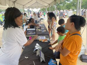
Working with ESRI’s Social Justice Team, National Geographic and some other partners, we built our “Ten States” Research Hub, which we debuted at the Reservoir Center. It has a series of story maps explaining how some of these communities came to be divested, predictive apps looking at Internet access versus different climate hazards and mini-dashboards that emergency managers can use to get real time risk data. This started with many of the Ten States communities wanting to raise awareness about the topic. Some of our community partners — especially our friends in Anacostia DC — have been using the story maps in their community education. They’ve popped up at resilience hubs and even in a series of environmental justice talks in local parks.
As a sidebar, besides the three years T-UP has been in existence in my academic roles, I have been working with some of these community organizations and leaders for upwards of seven years. We’ve built relationships with 250+ and growing in our network. We don’t utilize a “donor-beneficiary” approach but instead interact as peers and many times followers of these leaders. The result is that we can always ask for their insights because they know we won’t misuse this information and they feel safe telling us about issues because they know we will try our best to help in a respectful way.
3. Since many of the communities you build tools for are historically disconnected how do they find out about your tools and resources?
This is why having community partners, and treating them as true partners, is so important. Though you and I can view these tools online, they are all downloadable. We have made them available in known community anchor institutions like libraries and others that may surprise you, like the local John Deere dealer, to be shared with folks who are not connected. Many of the apps are also available for mobile devices and designed to be used offline or with low data needs so that people who are cell phone dependent can get this information without having to be concerned about cost.
4. Tell us more about the Ten States Project and where the idea for this hub came from.
While doing research with some of my students at Georgetown, we realized that when you exclude NYC and LA, most of the Afro-descendant and Latinx population in the U.S. reside in ten states. These are mainly in the Gulf South and Mid-Atlantic. These are also the states most prone to disasters like hurricanes, most prone to climate impacts like heat and sea level rise and are — wait for it — some of the most historically disconnected from Internet and other public infrastructure. It seemed necessary that our first large scale project focused on these states and building something that could raise awareness about these issues. We also wanted to open access to data and usable information for the communities in these places.
5. What are you most excited about when thinking about TUP’s work in 2026?
Three things. First, we are working on a disaster law and environmental justice law dashboard. With the lack of clarity about federal laws and protections, we are building tools that can surface state level resources and protections for communities. Also, I think it is important to help people have a baseline understanding of what is available to them. I hope that we can partner with some legal aid organizations and law schools to strengthen our outreach.
In 2026, we will be doing a lot of storytelling and campaigns. I recently finished a field project in Southeast Louisiana, so look for more from us about those wetlands and the cultures and communities within them. We are also planning an “undo the divide” campaign with more of our community partners to help others access our work and demand better information.
Finally, my (our) book “Climate and Code: Building Digital Justice In A Connected World” will be out in late spring 2026.